A Letter to the Supreme Court
On April 20, 2021, the California Court of Appeal overturned the lower court ruling that protected the West Berkeley Shelmound from a fast track building permit under SB35 and the City of Berkeley and Confederated Villages of Lisjan have petitioned the California Supreme Court to accept the case and reverse the appeal court decision. Sixteen excellent amicus curaie letters backing the city and the Ohlone were sent in (see links at bottom) and this is the letter written by Sacred Land Film Project Director Christopher “Toby” McLeod. The court should announce its decision in August—they accept 3-5% of cases submitted.
Honorable Chief Justice Tani Cantil-Sakauye and Associate Justices
California Supreme Court
350 McAllister, Room 1295
San Francisco, California 94102-4797
Re: Supreme Court Case No. S269012
City of Berkeley & Confederated Villages of Lisjan
v. Ruegg & Ellsworth and Frank Spenger Company
Amicus Curiae Letter in Support of Petition for Review
By Christopher McLeod, Sacred Land Film Project
June 27, 2021
Dear Chief Justice Cantil-Sakauye and Associate Justices:
I submit this letter as amicus curiae in support of the petition for review of Petitioners City of Berkeley and Confederated Villages of Lisjan. My interest in the West Berkeley Shellmound matter comes from 40 years as a documentary filmmaker and journalist in the San Francisco Bay Area, focusing on the efforts by Native Americans and other indigenous communities around the world to protect sacred sites.
I received a Master’s Degree in Journalism from UC Berkeley, a B.A in History from Yale, and have lived in Berkeley full time since 2009. My award-winning films, In the Light of Reverence (72 minutes, national broadcast on the PBS series POV in 2001) and Standing on Sacred Ground (four-hour series, national broadcast on the PBS World Channel in 2014), drew attention to cultural resource protection, sacred site destruction, and the failure of the U.S. court system to protect the heritage landscapes of Native Americans.
While I have great respect for the written word, I am a visual artist, and this letter incorporates several maps and graphics that I believe tell a clear and undeniable story about the West Berkeley Shellmound and are essential to understanding this three-dimensional conflict. These images help people visualize this complex story while revealing important details that the written word can confuse and obscure.
The California Supreme Court should grant review to settle important questions of law that have significance both in California and nationally. The appeal reversal was not based on the facts of the case or the evidence in the record, and it severely damages the causes of historic resource and cultural heritage protection in the state and nation.
In brief, in the appeal court decision: 1) The unregistered/unlicensed “archaeologist” Allen Pastron’s opinion is cited as evidence, and 2) The court of appeal not only missed the real evidence but also improperly dismissed a sacred site as a garbage heap.
Only an ethno-centric interpretation would deny that a 5,000-year-old ceremonial mound is a historic structure. A thriving maritime village lasting hundreds of human generations constructed an ever-growing elevated platform as a burial site, near a perennial fresh water source, in a meaningful cultural alignment with what we now call Alcatraz Island and the Golden Gate. This is a classic sacred site connected to a cultural landscape that carries resonance right through to today. Ohlone people continue to visit and pray at the site.
SB35 omits wetlands, toxic sites, conservation easements, endangered species habitat, and landmarked historic structures from fast track affordable housing consideration.
The trial court decision rightly recognized that a historic structure would be destroyed if developers dig down 11-feet into the landmarked archaeological site CA-ALA-307, also known as the West Berkeley Shellmound and Village Site, and Judge Roesch therefore showed respect for traditional cultural properties and Native California culture and history. The appeal court reversal in the name of housing and private property—even after Gov. Newsom’s apology drew attention to our state’s horrific history of genocide, and the California legislature amended SB35 via AB831 (aka AB168) specifically to correct the oversight that SB35 exemptions did not include “tribal cultural resources”—represents another historic, unjust setback. This reversal has statewide importance and national significance. It must not stand.
The National Register of Historic Places defines “STRUCTURE” as follows: “The term ‘structure’ is used to distinguish from buildings those functional constructions made usually for purposes other than creating human shelter.” It lists as examples: “…bridges, tunnels, gold dredges, firetowers, canals, turbines, dams, power plants, corncribs, silos, roadways, shot towers, windmills, grain elevators, kilns, mounds, cairns, palisade fortifications, earthworks, railroad grades, systems of roadways and paths, boats and ships, railroad locomotives and cars, telescopes, carousels, bandstands, gazebos, and aircraft.” (Emphasis added.)
I have worked on telling the story of the West Berkeley Shellmound through maps, graphics, blogs and short films for the past five years. Along with landscape designer Chris Walker, we designed a map that tells the whole story.
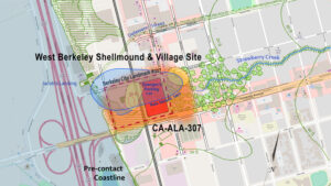
The two yellow ovals are the two shellmounds on the 1856 US Coast Survey Map. The blue oval is from the map by famed archaeologist Nels Nelson who delineated what he believed to be a single shellmound boundary in 1907 after most of the mound(s) had been carted away by Berkeley settlers. The City Landmark #227 boundary is shown with red dashes. The orange area with the intentionally fuzzy boundary is the archaeological site CA-ALA-307, which was found eligible for the National Register of Historic Places under all four categories in which sites are nominated (which is “very rare” according to archaeologist Christopher Dore). Note the overlapping yellow mound in the northwest corner of “Spenger’s Parking Lot” (1900 Fourth Street), the contested site. This is where Allen Pastron drilled Bore Hole #19. See text below, and additional map below.
Details on how this map was created are here.
It is the archaeological site CA-ALA-307 that has cultural, historic and archaeological value and needs to be protected, not just the shellmound(s), which due to subsidence would have significant presence underground extending outwards from the outer edge visible at the surface because (as explained in the excellent amicus letter from Kent Lightfoot, Lucy Gill and Jordan Brown) the weight of the mound pushed shell material and burials down into softer, wet bay mud at a rate of 1mm per year or roughly 13-16 feet over 4,000-5,000 years. The wider perimeter underground explains why Allen Pastron hit a 4-foot layer of shell at a depth of 5-9 feet in Bore Hole #19 in 2000.
This is the evidence the appeals court missed and Pastron and the developers have misrepresented.

This is a cross-section, below ground view of Pastron’s Bore Hole #19, looking east from the western edge of the property. This graphic by Chris Walker, was reviewed by Lucy Gill and Jordan Brown of University of California Berkeley’s Archaeology Department and deemed an accurate rendition of Pastron’s core samples.
Here is our map with Bore Hole #19 added:
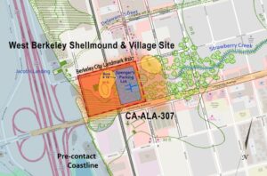
In 2014, when Allen Pastron was paid by the developers to go back and revisit the site, he used the crude technique of digging trenches with a backhoe. In 2000, in Bore Hole #19 he found “an abundance of Mussel and clam shell fragments, some oyster shell and some mammal bones” at 5-feet in depth, and “a significant amount of mussel and clam shell fragments” from 6-feet down to 9-feet. THAT IS EVIDENCE. When Pastron backhoed a series of trenches in 2014, Trench 21 was centered on Bore Hole #19. He reported “some flakes of clam and oyster shell” at a depth of 4.4 to 5.1-feet but then reports “end of excavation as trench was filling up with water.” He did not go below 5.1 feet.
Yet Appeal Court Justice Anthony Kline quotes Pastron verbatim in the appeal decision. Pastron’s 2014 report concludes: “Upon closer examination, we determined that Boring #19 probably did not originally contain intact shellmound between 5 and 9 feet below surface level, as we only encountered a thin layer of crushed shell” —but how can he know this if he did not go below 5.1-feet in 2014?
Pastron’s 2014 opinion is not based on evidence and the developers cannot wish away the actual evidence Pastron documented in Bore Hole #19 in 2000—a four-foot layer of shell.
The entire site has tremendous value. When archaeologist Christopher Dore nominated the site for the National Register of Historic Places his report stated the following about everything within the boundary of CA-ALA-307:
3.2 Application of Criteria
Archaeological resource CA-ALA-307 is classified as a site for this National Register evaluation. “A site is the location of a significant event, a prehistoric or historic occupation or activity, or a building or structure, whether standing, ruined, or vanished, where the location itself possesses historic, cultural or archaeological value regardless of the value of any existing structure.” (36 CFR 60) —Garcia and Associates (2002) “Cultural Resources Evaluation”
Professor Kent Lightfoot’s recent review of soil material taken from the shellmound in 1950 and stored at the Hearst Museum at UC Berkeley yielded invaluable new insights about the village, by using brand new techniques. First, tiny particles never analyzed before showed that the surprisingly fine detail of now-disintegrated fishing nets proved a high degree of sophistication in fishing techniques and indicated a much larger food supply than was previously understood, hence the size and longevity of the village. Second, the presence of previously unidentified particles of nuts, grasses and seeds indicated the villagers were conducting controlled burns throughout the area to encourage grasslands, to keep trees out, and thus to maximize food sources for people and prey like deer. This is the kind of potentially new information that will be lost forever if this site is destroyed.
The misleading strategy of the developers and their attorneys continues in their “Answer to Petitions for Review” to the California Supreme Court: “As the court of appeal concluded, however, no evidence shows there is a historic structure on the site. It is a parking lot.” (petition filed June 16, 2021)
An expensive public relations campaign and sternly worded legal briefs cannot obscure the fact that an important cultural landscape and designated historic landmark—a sacred site—still graces West Berkeley where Strawberry Creek once flowed freely into the bay and where a hundred generations of Ohlone villagers built the massive mound of shells that nurtured the remains of revered ancestors. What is most troubling about this well-funded propaganda campaign is the misinformation being presented to accomplish the goal of defeating a determined and effective Ohlone resistance so that an outside developer can build a multi-million dollar cash machine on a sacred site. This PR campaign has been going on for years:
“There is nothing at all of any cultural or historical significance on this property.”
— Lauren Seaver, West Berkeley Investors / Blake Griggs Properties, in a press release (March 8, 2018)
Put simply, this is a false narrative. As explained above, the developer’s own hired archaeologist found part of the shellmound and cultural resources within the project site. But it is very important to also note that the developer’s focus on the location of the shellmound is a diversionary tactic meant to confuse. The exact location of the shellmound or shellmounds is less important than the fact that this is the site of an ancient Ohlone settlement with countless burials and archaeological evidence of centuries of human life. Ohlone villages often were comprised of a mound complex with one large mound and satellite mounds. This conflict is about a cultural landscape, a recognized archaeological site, known as CA-ALA-307—the 307th shellmound of 425 around San Francisco Bay catalogued by famed archaeologist Nels Nelson in 1904. This oddly named #307 is the heart of an ancient village site with reliable fresh water that supported 5,000 years of human habitation and generated more than one shellmound burial structure.
In his comment letter on the DEIR, archaeologist Christopher Dore wrote: “The shellmound is one archaeological feature within the boundaries of CA-ALA-307. There are significant, undisturbed, cultural and natural deposits within CA-ALA-307 that are not directly related to the shellmound… One of the names for CA-ALA-307 that has been used historically is West Berkeley Shellmound. This is just a ‘shortcut’ name for this entire historical resource; both the parts that relate to the actual shellmound (the archaeological feature) and other archaeological components of the site within the site boundary…” The developer “looks at the parcel in isolation, and this is in error given that it is in the middle of a significant archaeological site. Cultural resources must be examined as a whole and in their context.”
The City Landmark Designation in 2000 noted: Landmark to “include the Strawberry Creek creek bed… and native or historic articles found beneath or around Spenger’s parking lot.”
Chris Dore’s DEIR comment letter on the 1900 4th St. project concluded that “given the archaeological and historical data demonstrating that a large number of human remains have, and continue to be, discovered within the boundaries of CA-ALA-307, the probability of human remains within the project parcel is high.”
Registered Professional Archaeologist Stephen Bryne, who conducted archaeological work at the West Berkeley site on behalf of the city in 2001-2002, stated in his comment letter to the DEIR: “I feel that the Archeo-Tec report is flawed. The Archeo-Tec (2014) report, while it appears to support the [1900 Fourth] project, does not agree with nearly all of the earlier archaeological findings, including Archeo-Tec’s own (2012) results, regarding this important prehistoric site.”
Finally, we note that in 2002, Chris Dore drilled core samples in the streets on three sides of Spenger’s parking lot for a city of Berkeley cultural resource assessment related to planned work on the nearby Amtrak train station. (He only drilled into Berkeley streets and did not investigate private property, such as 1900 Fourth St.) Dore’s map shows seven bore holes with “Intact Cultural Deposits” and two with “Disturbed Cultural Deposits” all within a few feet of the property boundary. In the text corresponding to the map (below), bore hole U-81 has “Very rich shell and ash lens” and U-78 has “Rich shell midden.” Spenger’s Parking Lot is outlined in red.
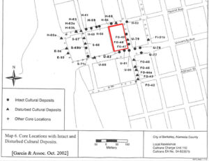
“Our coring identified undisturbed, intact cultural deposits right next to Spenger’s parking lot and wrapping around it,” Mr. Dore told me in a phone interview on May 14, 2018. “How can there be nothing there when there are cultural deposits all around it?”
This evidence is conclusive. The shellmound is a “historic structure” listed on local, state and national landmark registers, and Bore Hole #19 proves that cultural deposits from the original shellmound underlie the property at issue. The California Supreme Court should take this case and reverse the appeal court’s erroneous decision in which important evidence was ignored.
Thank you very much for your time.
Sincerely,
Christopher McLeod
Director, Sacred Land Film Project
Auburn Rancheria
LEGAL PETITIONS FOR REVIEW:
Blog Post Categories: Blog, SLFP News, Threatened Sacred Sites, West Berkeley Shellmound