Tiwanaku and Lake Titikaka
| Status | Protected |
| Country | Bolivia |
| Report By | Zoe Scheffy |
| Posted | July 2, 2019 |

Tiwanaku (or Tiahuanacu) is an ancient civic and sacred site consisting of former pyramids and enclosures, gateways and monuments located in western Bolivia near the southeast shore of Lake Titikaka. Tiwanaku was both the political and spiritual capital of the Tiwanaku Empire between 200 and 1000 CE and was an integral part of the spiritual traditions of the Lake Titikaka region, whose elements can be seen in the sculptures and carvings on the structures at the site. Standing at an altitude of 12,630 feet (3,850 meters), the extensive archaeological site has been studied and excavated since the 17th century and has suffered destruction from colonial and industrial powers. In 2000, Tiwanaku was designated a UNESCO World Heritage Site, and today it is a national museum and site of political importance, as well as a significant cultural and religious site for the indigenous Aymara people of Bolivia.
The Land and Its People
The Tiwanaku inhabited parts of Bolivia, Peru and northern Chile from approximately 1500 BCE to 1000 CE and spoke Pukina (Puquina). While Pukina is no longer spoken, descendants of this language group exist today in the same region, and remnants of Pukina can be heard in both the Quechuan and Spanish languages, as well as in the Kallawaya language of the nomadic traditional healers in the Andes of Bolivia.
Tiwanaku, as a geographic area, sits between the shores of Lake Titikaka and dry highlands, in Bolivia’s Province of Ingavi, Department of La Paz. The site was originally populated as an agricultural village. Due to favorable climate with abundant and predictable rain, which made the location ideal for farming and large-scale agriculture, Tiwanaku grew in spiritual and administrative importance and became the heart of the Tiwanaku Empire around 200 CE. The urban, architectural complexes that remain today were built beginning in 400 CE. At the peak of the empire’s political power between 500-950 CE, the population soared to between 30,000 and 70,000 people. Residents of Tiwanaku colonized and traded with many neighboring communities in the Lake Titikaka region, and the empire’s reach encompassed a territory extending from present-day northern Argentina and Chile through Bolivia and southern Peru. Tiwanaku’s strength and influence was bolstered by astute agricultural and architectural engineering and impressive spiritual and ceremonial display.
The demise of the Tiwanaku Empire began around 950 CE due to significant shifts in climate. The Titikaka Basin suffered from extreme drought and the agricultural prosperity of the empire waned. The population dispersed to other areas and many people perished. The city was abandoned and the Tiwanaku Empire had dissolved by 1000 CE.
The Inca people who later populated the shores of Lake Titikaka and surrounding highlands incorporated Tiwanaku into their own mythology and worldview, building upon the legacy of the powerful empire. Today, Tiwanaku remains a significant spiritual site for the Aymara people who live in this region of Bolivia.
Spirituality, Lake Titikaka and Ancient Tiwanaku
The Tiwanaku Empire connected spirituality, power and authority between the physical space of Lake Titikaka and the highland site of Tiwanaku. Temples were built at both sites and the shared imagery of the snake, condor and puma are significant in the religious and cosmological expressions that linked the two sites.
Several scholars have pointed to the connection between the spirituality, agricultural patterns, monumental architecture and artistic depictions of the Tiwanaku to earlier and other regional cultures, such as Chiripa, Pucara and Cusco. Known as the Yaya-Mama Religious Tradition, many artifacts discovered in the Lake Titikaka region feature similar motifs and show a long integration within the geography and cultures of the region.
Lake Titikaka was the spiritual birthplace and center of the cosmos in the Tiwanaku and Incan worldviews and remains a sacred site for the indigenous peoples who continue to live in the region. Lake Titikaka is named for the puma, a spiritually powerful animal. In the modern-day Quechua language, titi means puma and kaka means mount, while in Aymara titi means puma and k’ak’a means white- or grey-haired.
According to Incan mythology, which followed the Tiwanaku by hundreds of years, the god and great creator Viracocha emerged from Lake Titikaka to create the world after a great flood. He brought the Sun (Inti) out of the Island of the Sun near the southern shore of Lake Titikaka in present-day Bolivia, the Moon (Mama Killa) out of the Island of the Moon to the east, and created the cosmos with stars born from the lake. Viracocha then created the first humans at Tiwanaku out of stone. Viracocha was an omnipotent god who controlled the elements, the weather and agricultural fortune.
Viracocha is depicted at Tiwanaku on the Gateway of the Sun and is featured in other carvings and imagery of the ancient empire. Like the god of the Incas, he is seen holding a snake in each hand whose head is that of a condor. Viracocha was also associated with the sun and lightning. Also featured on the Gateway of the Sun, on either side of Viracocha, are figures with condor heads looking toward the sky.
International archaeological excavations in 2000 and 2002 revealed a temple submerged in Lake Titikaka that dates to the Tiwanaku Empire. It is thought that the temple was submerged after an earthquake or rising water levels over the millennia. Today the temple is visible during periods of drought. Featuring a long road, a 2,625-foot (800-meter) retaining wall, and terraced field for crops, this temple—which covers an area the size of a soccer field—was made of large interconnecting stones. Divers found large block carvings of snakes and brought up artifacts depicting puma created out of stone and gold. The site conveys the reach and religious organization of the Tiwanaku Empire and embodies the deep spirituality of the entire region.
Tiwanaku Sacred Site
Today the site called Tiwanaku, in the highlands above Lake Titikaka, consists of nine excavated structures and a contemporary museum describing the Tiwanaku people, the history and spirituality of the site, archaeological efforts, and the significance of the site to modern-day Bolivia. The nine structures are:
- Akapana Pyramid
- Kantatallita Temple – Subterranean
- The Monolito Ponce
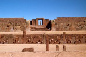
- Kalasasaya Temple
- Puerta del Sol (Gateway of the Sun)
- Puerta del Luna (Gateway of the Moon)
- Kerikala enclosure
- Putuni enclosure
- Puma Punku
Tiwanaku was built with highly-planned engineering, astronomical understanding and aqueducts. Both for agricultural efficiency and spiritual significance, the city and temples were originally surrounded by a moat and series of waterways. The moat created the illusion that Tiwanaku was an island, invoking the religious significance of the islands of Lake Titikaka. In addition, the presence of the Gateway of the Sun and the Gateway of the Moon mirrored the islands of the Sun and Moon in Lake Titikaka, establishing the cosmological connection of both locations to the Gods.
The builders of Tiwanaku positioned the site in line with the cardinal directions, and the Gateway of the Sun served as an astronomical calendar, tracking the sunset with the use of a pillared wall. The Gateway of the Sun divided the year into ten months with 36 days each, marking the annual solstices and equinoxes, and tracking lunar eclipses in accordance with the “Saros Cycle.”
 Akapana Pyramid
The Akapana stepped pyramid stands 59 feet tall and was one of the largest and highest structures at Tiwanaku. At its start, the site was an arrangement of small single homes, but later Akapana was constructed into large square compounds. By 950 CE construction of the monument ended and stones were left in various stages of fabrication, scattered around the partially built monument. In the following centuries looting and quarrying of the stones were the source for colonial churches and a railway built in the 1900s.
 Kantatallita Temple
Kantatallita means “exposed to the dawn” or “light of the dawn.” The Kantatallita Temple consists of carved relief monoliths in a large open area. The square sandstone blocks weigh approximately 44,000 pounds (20,000 kilograms).
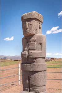 Monolito Ponce
Named in honor of the Bolivian archaeologist Carlos Ponce Sanguinés, the Monolito Ponce is a statue of a human figure approximately 9–10 feet tall (3 meters). By some accounts it is the image of a shaman holding two religious implements. The figure’s right and left hands are positioned differently about the implements, and the figure’s face is adorned with decoration.
 Kalasasaya Temple
Kalasasaya means “stopped stones.” The temple is a low platform mound measuring 393 by 426 feet (120 x 130 meters) with a large courtyard surrounded by high stone walls. Like other platform mounds within Tiwanaku, the Kalasasaya Temple has a large staircase to the east that leads to a central sunken court. The walls are composed of sandstone pillars that alternate with sections of smaller blocks of ashlar masonry. An outstanding feature of the Kalasasaya Temple are the tenon heads in diverse styles that run along the outer walls, reconstructed in modern times at the sacred site. The heads may have represented the many communities the Tiwanaku empire colonized. The archaeologist Artur Posnansky described the temple as an “almanac of carved stone.”
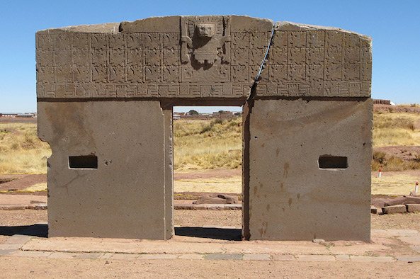
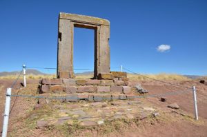
Puerta del Sol
 Puerta del Sol stands at the eastern side of Tiwanaku within the courtyard of the Temple of Kalasasaya and means “Gateway of the Sun.” The gateway features petroglyphs depicting humans and animals, and many researchers have interpreted the gateway to be a solar-lunar calendar with similarities to later Aymara and Inca traditions. The gateway is part of a physically larger annual calendar that includes a stone wall consisting of eleven pillars that tracks the setting of the sun along the horizon throughout the year, as well as the winter and summer solstices, and spring and autumn equinoxes. The symbols carved on the lowest line of imagery on the gateway mark this astronomical passage of time throughout the year, whereas the symbols featuring the head of a condor on the upper three lines signify complete years.
Today the gateway stands in a different position within Tiwanaku, due to human activity from looting and archaeological inquiry. Therefore, it is not in its original position in line with the pillars and wall, and the calendar does not function as designed.
 Puerta del Luna
Puerta del Luna (“Gateway of the Moon”) stands in the northeastern section of Tiwanaku beyond the Putuni enclosure. This gateway features similar symbols to those seen on the lowest line of Puerta del Sol, marking the astronomical passage of time. However, on Puerta del Luna there are seven similar markings, rather than the eleven markers that connect Puerta del Sol with the wall of pillars.
Puerta del Luna has not been studied as much as Puerta del Sol and there does not seem to be a wall of pillars that works in concert with the gateway. Therefore, the symbols may have been read with a direct eye to the heavens. The presence of gateways recognizing the power of both Viracocha and Mamakilla—the sun and moon, men and women—at Tiwanaku is significant. It is not clear if the gateway stands in its original position.
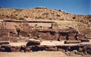
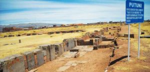 Putuni
Putuni is a large, rectangular enclosure measuring 180 x 200 feet (55 x 60 meters). The structure is surrounded by double walls and features burial chambers. The building housed the remains of people important within the Tiwanaku hierarchy. Putuni was built with a complex sewage system. The name Putuni is understood by way of the Aymara word putuputuni, meaning “where the gaps are,” and is also referred to as the Palace of the Sarcophagi.
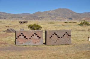
 Kerikala
Near Putuni are the Kerikala—“stones that burn” or “fire stones.” These carved pillars were set alight and provided illumination.
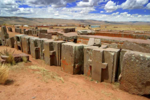 Puma Punku—Pyramid Complex
Puma Punku means “Door of the Puma” in the Aymara language, one of Bolivia’s official languages which is spoken by more than one million people in the Andes. The Puma Punku Pyramid is a large stepped platform mound resembling a square with three levels of stone retaining walls. Posnansky also called the pyramid the “Temple of the Moon.” The complex was used for ritual and ceremony.
The Puma Punku complex consists of a terraced platform with an unwalled courtyard to the west and walled courtyard to the east. At the peak of its use by the Tiwanaku empire, Puma Punku is thought to have been highly decorated with polished metal plaques, brightly colored ceramic and fabric.
Tiwanaku, Colonization and the Church
The architectural features and artifacts of Tiwanaku have suffered from collapse, looting, destruction, and amateur excavations, since the end of the Tiwanaku empire. During the Spanish conquest of the Inca empire beginning in 1532, and in the colonial period that followed, silver mining and quarrying for railroad construction during the 19th and 20th centuries damaged the site, while target practice by military personnel also scarred the structures of Tiwanaku.
Iglesia de San Pedro de Tiahuanaco was built between 1580–1612 CE and was declared a national Bolivian monument on January 31, 1945. The church, which is located in the town of Tiwanaku, very near the ancient structures described above, was designed by the Catholic Church during the initial period of colonization to synchronize Incan cosmology with the Catholic canon.
Iglesia de Tiahuanaco was built with bricks and incorporates blocks taken from Tiwanaku. The church features stone gargoyles depicting Titi, the puma. Two monoliths, similar to the Monolito Ponce, which were taken from the Pokotia region south of Tiwanaku, stand on either side of the doorway.
Destruction and Archaeological Excavation
The curiosity and imaginings of travelers and amateur archaeologists during the 19th century brought attention to the magnificence and significance of Tiwanaku. According to John W. Janusek (“Tiwanaku and Its Precursors: Recent Research and Emerging Perspectives,” 2004), the sacred site was interpreted to be a ceremonial center and “beds of ash” were thought to be the result of rituals. This curiosity influenced the archaeological studies that would follow, but also gave rise, in some cases, to the reorganizing of the site and its objects for tourist photography and travel accounts destined for broader public consumption abroad.
By the mid-19th century early academic studies and earnest research of the structures at Tiwanaku began. American archaeologist and journalist Ephraim George Squier visited Tiwanaku in the 1860s and later published maps and drawings of the site. He was the United States Commissioner to Peru and studied Inca ruins in the region. Likewise, German geologist Alphons Stübel traveled to Bolivia in 1876 and stayed in Tiwanaku for approximately nine days. He made sketches and rubbings of carvings and architectural features and created a detailed map of the ancient site based on careful measurements. Likewise, in 1892, archaeologist and philologist Max Uhle, a friend of Alphons Stübel, published The Ruins of Tiahuanaco in the Highlands of Ancient Peru, with engineer and photographer B. von Grumbkow. The book was an in-depth, scientific examination of Tiwanaku.
One of the most influential archaeological excavations of Tiwanaku was undertaken in 1903–4 by Artur Posnansky, an Austrian-born Bolivian soldier, entrepreneur, council member and archaeologist. A staunch supporter of Bolivia during the Bolivian-Brazilian land dispute at the turn of the 20th century, and prosperous businessman and government leader in La Paz, Posnansky channeled his enthusiasm for his adopted country into detailed studies of Inca and pre-Inca civilizations, including Tiwanaku and the Lake Titikaka region.
Posnansky sought to highlight the architectural and spiritual significance of Tiwanaku and the people who created, lived and worshipped there. Seeking to go beyond the accounts of “chroniclers and travelers, as well as those of dilettantes,” and to preserve the site for American scientific study against irreparable loss caused by the railroad (Tihuanacu, the Cradle of American Man, Vols. I – II, 1945), Posnansky meticulously mapped the ruins and shot a plethora of photographs of the monuments, statues and gateways. While Posnansky mistakenly estimated the Tiwanaku civilization to be much older that it was, and may have misinterpreted the meaning of some of the structures and artifacts, his study of the site and its engineering and his creation of maps and documentary resources have supported subsequent research and excavations and helped to preserve Tiwanaku as one of Bolivia’s national heritage sites.
During the 20th century, Bolivian archeologists Carlos Ponce Sanguinés (1925–2005) and Georgio Cordero Miranda (1922–1979) excavated and rebuilt Tiwanaku as we see it today. Sanguinés began his archeological work with Tiwanaku ceramics in 1947 with Miranda providing illustrations. Ultimately Sanguinés directed national Bolivian archaeology and headed the modern reconstruction of Tiwanaku beginning in the 1960s.
From 1978 through the 1990s, the National Director of Bolivian Archaeology Oswaldo Rivera worked with international teams, including University of Chicago anthropologist Alan Kolata, to continue research and excavation at Tiwanaku. Today the site is still only partially excavated and a new cohort of archaeologists, including Alexei Vranich, are continuing research and reconstruction of Tiwanaku through both traditional and innovative methods, including the use of 3D printing copies of the stones and structures in order to enhance understanding.
Preservation and National Significance
Today Tiwanaku is a focus of both national Bolivian and Aymara ethnic pride and identity, connecting the modern citizenry with a powerful ethnic, geospiritual and geopolitical past. Bolivia is the custodian of Tiwanaku, from the islands and submerged temple in Lake Titikaka near Copacabana, to the ruins and structures in the highlands by La Paz. Tiwanaku is visited annually by Bolivian schoolchildren and used for national public ceremony.
The Bolivian government has been committed to the protection and conservation of Tiwanaku through national and local efforts since 1906, and safeguarding the site is enshrined in Bolivia’s constitution. As part of becoming a UNESCO World Heritage Site in 2000, Bolivia developed a ten-year conservation plan (1999-2009) that included archaeological investigations, conservation and restoration, anthropological research, and would address infrastructure and administration of the site.
The Aymara who live in and around La Paz and Tiwanaku are connected to the site in varied and complex ways with regard to definitions of ethnic belonging and economic opportunities at Tiwanaku with tourism and site management (Sammells 2013). The Aymara have inhabited the region for about a thousand years, and they built powerful communities around Lake Titikaka after the fall of Tiwanaku. Today the Aymara are one of the largest indigenous groups in Bolivia, which is a majority indigenous nation-state, and, while the Aymara were not the originators of Tiwanaku, present-day communities hold cultural and spiritual ceremonies at the sacred site. Tiwanaku has become integral to a meaningful indigenous, anti-colonial identity in Bolivia.
Of powerful significance has been the use of Tiwanaku for political public events. President Evo Morales—who is Aymaran and Bolivia’s first indigenous president—has held his presidential swearing-in ceremonies at Tiwanaku accompanied by Aymaran spiritual practitioners. Adorned in traditional textiles, President Morales addressed supporters from the Akapana Pyramid and participated in a ritual blessings by Aymara priests at the Gateway of the Sun. Calling upon the historical and political significance of the site, President Morales’ ceremonies sought to link him ethnically, politically and spiritually with the ancestors and the geopolitical space, and to give historic legitimacy to his leadership.
Likewise at a Winter Solstice ceremony held at Tiwanaku in 2016, President Morales proposed using the Tiwanaku calendar in Bolivia, rather than the Christian Gregorian calendar brought by the Spanish during colonization. Based on the passage of the sun and using a 28-day month and 13-month year, the Tiwanaku calendar acknowledges and celebrates the agricultural practices still in use by modern Aymara communities and elevates indigenous culture, worldview, cosmology and importance within the Bolivian nation-state.
Sources
Allen, Jim. “Tiwanaku Soli Lunar Calendar.”
Ballvé, Teo. “The Declaration of Tiwanaku,” The North American Congress on Latin America (NACLA), September 25, 2007.
BBC. “Bolivia leader Morales wants to ditch Gregorian calendar.” June 22, 2016.
Browman, D.L., 2005. “Carlos Ponce Sangines, Godfather of Bolivian Archaeology.” Bulletin of the History of Archaeology, 15(1), pp.16–25.
Chavez, Karen L. Mohr. “The Significance of Chiripa in Lake Titicaca Basin Developments,” University of Pennsylvania Museum of Archaeology and Anthropology, Volume 30, 1988.
Chávez, Sergio J. “Agricultural Terraces as Monumental Architecture in the Titicaca Basin: Their Origins in the Yaya-Mama Religious Tradition.” Early New World Monumentality, edited by Richard Burger and Robert Rosenswig. University Press of Florida, 2012; pp 431-453.
Díaz Romero, B. (Belisario). Tiahuanacu; Estudio de Prehistoria Americana. La Paz, Impr. Artística de Castillo y c.a, 1903.
Doore, Kathy. “Puma Punku & Tiwanaku Tiahuanaco – Tiahuanacu.”
Dhwty / Ancient Origins. “The Ancient Ruins On and Beneath the Sacred Lake Titicaca,” September 11, 2018.
Friedman, Leslie A., “The Making of Place: Myth and Memory at the site of Tiwanaku, Bolivia.” Architectural Conservator, Los Angeles, California, USA.
Grey, Martin. “Tiahuanaco (Tiwanaku)” in Places of Peace and Power.
Holton, Graham. “Appropriating Tiwanaku: Evo Morales and the Politics of Bolivia’s Indigenous Past.”
Janusek, John W. “Residence and Ritual in Tiwanaku: Hierarchy, Specialization, Ethnicity, and Ceremony,” Domestic Life in Prehispanic Capitals: A study of Specialization, Hierarchy, and Ethnicity. Edited by Linda R. Manzanilla and Claude Chapdelaine. Memoirs of the Museum of Anthropology, University of Michigan #46. Studies in Latin American Ethnohistory & Archaeology, Joyce Marcus, General Editor Volume VII, 2009; pp 159-180.
Janusek, John W. “Tiwanaku and Its Precursors: Recent Research and Emerging Perspectives,” Journal of Archaeological Research, Vol. 12, No. 2 (June 2004), pp. 121-183.
Katz, Brigit. “Archaeologist Reconstructs Ruins of Tiwanaku Temple in Bolivia Using 3-D Printing Technology.” December 17, 2018.
Posnansky, Artur. Tihuanacu, the Cradle of American Man, Vols. I – II, 1945.
Sammells, Clare A. “Complicating the Local: Defining the Aymara at Tiwanaku, Bolivia.” International Journal of Historical Archaeology. Vol. 17, No. 2, Special Issue: The Ethics of Archaeological Tourism in Latin America (June 2013), pp. 315-331.
Staller John E. and Brian Stross. Lightning in the Andes and Mesoamerica: Pre-Columbian, Colonial, and Contemporary Perspectives. Oxford University Press, 2013.
Vranich, Alexei. “The Construction and Reconstruction of Ritual Space at Tiwanaku, Bolivia (A.D. 500-1000),” Journal of Field Archaeology, Vol. 31, No. 2 (Summer, 2006), pp. 121-136.
UNESCO. “Tiwanaku: Spiritual and Political Centre of the Tiwanaku Culture.”
Wiener, Charles. Pérou et Bolivie -Récit de voyage suivi d’études archéologiques et ethnographiques et de notes sur l’écriture et les langues des populations indiennes, Paris, Librairie Hachette, 1880.
Young-Sanchez, Margaret (editor). Tiwanaku: Ancestors of the Inca. Denver Art Museum, University of Nebraska Press 2004.
Continue Exploring Sacred Sites
 Explore a world of sacred lands and discover more than 100 site reports using our interactive map.