Propaganda vs. Facts at West Berkeley Shellmound
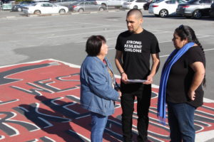
Attack on Berkeley Sacred Site Continues
After a two-year battle, the Ohlone campaign to protect the West Berkeley Shellmound and Village Site suffered a surreal setback in March, when the developer invoked a new state law that takes control of housing project approval away from local zoning boards and city councils and requires “over-the-counter” approval by planning departments. In the face of massive community opposition to their original proposal, the 1900 4th Street developers totally redesigned the project to meet the requirement of SB 35 (which went into effect in January) that half of the units be “affordable.” A threatening 12-page letter to the City of Berkeley basically said approve this project within 180 days or face a lawsuit. The press release announcing the new plan went out 20 minutes before the press conference, and the event was staged miles to the south in Emeryville, not Berkeley. A well-publicized press conference in Berkeley might not have gone well.
The Developer’s Strategy
After 1,800 letters flowed into the Berkeley Planning Department commenting harshly on the 2017 Draft Environmental Impact Report (DEIR) — with just five letters in favor of the project — developer Blake Griggs and landowner Ruegg & Ellsworth knew they had a serious problem. Their 2.2 acres sit at the heart of an archaeological site of national significance. To overcome these obstacles, a team of well-paid lawyers and PR consultants have set out to strategically deny, diminish and discredit the cultural and historic value of the property.
But an expensive public relations campaign cannot obscure the fact that an important cultural landscape and designated historic landmark — a sacred site — still graces West Berkeley where Strawberry Creek once flowed freely into the bay and where a hundred generations of Ohlone villagers built a massive mound of shells that nurtured the remains of revered ancestors. What is most troubling about this well-funded propaganda campaign is the misinformation being presented to accomplish the goal of defeating a determined and effective Ohlone resistance so that an outside developer can build a multi-million dollar cash machine on a sacred site.
Let’s look at some of the misinformation and set the record straight — facts versus fiction in the era of “alternative facts.”
Facts vs. Fiction
“There is nothing at all of any cultural or historical significance on this property.”
— Lauren Seaver, West Berkeley Investors / Blake Griggs Properties, in a press release
‘The site is void of cultural and historic resources.’
FICTION: The shellmound was not located on the 2.2 acres known as Spenger’s parking lot, the proposed site of the 1900 Fourth St. housing project.
FACT: Put simply, this is a false narrative. The developer’s own hired archaeologist found part of the shellmound and cultural resources within the project site. The developer’s focus on the location of the shellmound is a diversionary tactic meant to confuse. The exact location of the shellmound or shellmounds is less important than the fact that this is the site of an ancient Ohlone settlement with countless burials and archaeological evidence of centuries of human life. Ohlone villages often were comprised of a mound complex with one large mound and satellite mounds. This conflict is about a cultural landscape, a recognized archaeological site, known as CA-ALA-307 — the 307th shellmound of 425 around San Francisco Bay catalogued by famed archaeologist Nels Nelson in 1904. This oddly named #307 is the heart of an ancient village site with reliable fresh water that supported 5,000 years of human habitation and generated more than one shellmound burial structure.
In his comment letter on the DEIR, archaeologist Christopher Dore wrote: “The shellmound is one archaeological feature within the boundaries of CA-ALA-307. There are significant, undisturbed, cultural and natural deposits within CA-ALA-307 that are not directly related to the shellmound… One of the names for CA-ALA-307 that has been used historically is West Berkeley Shellmound. This is just a ‘shortcut’ name for this entire historical resource; both the parts that relate to the actual shellmound (the archaeological feature) and other archaeological components of the site within the site boundary…” The developer “looks at the parcel in isolation, and this is in error given that it is in the middle of a significant archaeological site. Cultural resources must be examined as a whole and in their context.”
In a recent confrontational email exchange that was forwarded to me, local historian Richard Schwartz demanded that the developers cease to use his research into the locations of burials found in the area around 1900 4th Street. Schwartz has documented more than 450 burials in the immediate area. The exchange was so full of misinformation from the developer that archaeologist Chris Dore was compelled to enter the fray and comment:
Dear Ms Seaver:
I really have no business jumping in here, but need to since I was copied on this e-mail and the archaeological facts in your e-mail are incorrect. You are very mistaken. There has been a lot of evidence presented, both professionally and in the public environmental process, that the 1900 4th parcel sits in the middle of CA-ALA-307. This site is an archaeological site determined eligible for listing in the National Register of Historic Places and listed on the California Register of Historical Resources. It was recommended eligible for listing under all four eligibility criteria (very rare) and demonstrated to have integrity. Where the shellmound, which is just one of likely many archaeological features in this site, is or isn’t located (and archaeologists do know exactly where it is located) is not relevant for the City of Berkeley’s compliance with the California Environmental Quality Act and for their consideration in granting a development permit.
Sincerely,
Christopher D. Dore, Ph.D., Registered Professional Archaeologist 10331
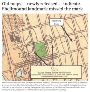
To help people visualize this story, local artist Chris Walker and I have created a series of maps to tell the story of the Ohlone shellmound and village site. We invite you to take a few minutes to explore Berkeley’s ancient and modern history, based on a U.S. government Coast Survey map from 1856 that actually showed not one but two shellmounds at the heart of the village. In this case, 16 pictures are worth a million words.
 1856 Coast Survey Map shows two shellmounds (dotted red lines)
Wind and water eroded shellmounds for centuries but human shovels would do the real damage.


‘The entire site was a swamp.’
FICTION: The developer claims the site was nothing but marsh.
Attorney Jennifer Hernandez, representing the developer, told the San Francisco Chronicle on March 8 that the investigation of potential American Indian resources “confirmed that this former marshland did not have any cultural resources or other evidence of artifacts.” The West Berkeley Investors press release asserted: “The project has faced local opposition from those who argue that the site should remain a parking lot because of concerns that development could contain historic or cultural resources. However, a multi‐million‐dollar research effort summarized in the project’s Environmental Impact Report (EIR) shows the site to be void of such resources. The research includes archaeological research including 43 borings, 22 test trenches, ground‐penetrating radar, and geological investigation as well as extensive historic research including discovery of U.S. Government maps from the 1800s confirming the parking lot was marshland never inhabited by humans.”
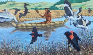
FACT: The developer’s own hired archaeologist found part of the shellmound and cultural resources within the project site. The 1856 Coast map (sequence above) does show the Strawberry Creek estuary underlying the southern portion of the property, and indeed, this is why the village was there, and very much “inhabited by humans.” The contact between shoreline and fresh water birthed a source of tule and willow for those humans to make canoes and homes, and offered a vital source of food in the form of shellfish, salmon and ducks. The solid ground shown on our historic map extends fully across the northern one third of the parking lot, between two well-used burial grounds — clearly a central place for ceremony and village activity. And remember, this is about a cultural landscape, a prehistoric archaeological site that fully encompasses the surrounding three city blocks and provided the sacred source of life, water.
The developers use the pejorative marsh, akin to swamp. Let’s use ecological language: this was a rich wetland. But how much of the property was wetland? Here again, the developer stumbles. Their PR variously claims the site was total wetland, but elsewhere says the 2.2 acres were two-thirds marsh and in another place, four-fifths marsh:
 “The site is located at the historical mouth of Strawberry Creek where the creek emptied into San Francisco Bay to the west. The site was covered by a marshy lagoon at the outflow of the creek” (p62 in objective standards document submitted to the Berkeley Planning Dept), and they also cite a geotech report that found “the southern two thirds of the site to have been occupied by a willow grove marshland (circa 1950)” (p63 in objective standards doc) and on the same page they assert that marshland comprised the “southern four-fifths of the site” with “the northernmost portion of the site to be part of the land mass outside the marsh area” (p63 in objective standards doc).
So, we have established that one-third of the site, perhaps one-fifth, in the developer’s own estimation was solid ground, land mass. That would have been an important part of the village, with access to fresh water, willow to shape houses, tule to build canoes, and food sources from waterfowl and seafood. UC Berkeley archaeologist Kent Lightfoot points out that “where there is a creek there are often mound clusters.” Professor Lightfoot told me the other day: “That’s a central spot in the mound cluster. It was all being used. It’s the landscape that is important. It’s sacred space — one of the earliest of these great sites around San Francisco Bay. It’s a very, very significant site.” One could conjecture that the land between the two shellmounds might have been an important place of ceremony when ritual burials and mourning would go on for four days.
Here’s a graphic the developers present in their PR materials:
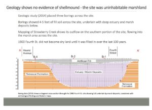
This is a strange graphic because it shows Hearst Ave. on one side and Fourth St. on the other, and those two streets are actually perpendicular. They cross each other at the northeast corner of 1900 4th St. The developer states this is a diagonal section across the lot, but it is hard to figure out what they are showing. All marsh? Two thirds? Four fifths?
While we are on the subject of the developer’s graphics — and let’s remember that it is not about where the shellmounds are located — here are three maps the developer has labored to produce to prove the shellmound(s) is not on Spenger’s parking lot. In the second/middle map below (where the dashed lines represent solid ground meeting wetland and two hashmarked rings depict two shellmounds) note how much of the property was solid ground, and not “marsh.”
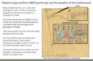

Developer’s map showing various different attempts to define the location of the two shellmounds. Remember: the shellmounds are features within a larger, designated, historic, landmarked village site. While pinning down their location may be an interesting exercise, I’m including this map just to show how various mapmakers have tried over the years to interpret earlier maps to determine where the shellmounds were located, some of which do show the main western mound overlapping the northwest corner of what is now “1900 4th Street.” Note: a) Strawberry Creek coming down from the east to flow into the tidal estuary — the source of many of those shells, and b) solid ground at the north of the site, between the mounds.
‘There is no physical evidence.’
FICTION: The developer claims to have investigated the site and found no physical evidence of shellmound, cultural artifacts or burials under Spenger’s parking lot. Lauren Seaver asserts: “We undertook archaeological, geological, historical studies on the property. A shellmound was never present on the site.”
FACT: The developer’s archaeologist, Allen Pastron of Archeo-Tec, actually reported finding part of the shellmound along with other cultural resources within the project site in 2000 and 2014, but changed his evaluation and conclusions in 2014. Remember, the developer’s strategy hinges on interpreting the West Berkeley Shellmound site in the narrowest possible terms, by isolating the historic mound itself, which is only one feature of the landmarked and registered archaeological, cultural site CA-ALA-307. So let’s look first at the Berkeley Landmarks Commission, and the reasons the site was landmarked by the commission 18 years ago and designated an important historic site.
The Landmark Application in 2000 — which is a good read and full of interesting history — states right up front that the landmark application is also for “the Strawberry Creek creek bed…and any native or historic articles found beneath or around Spenger’s parking lot.” The point here is that the developers, by asserting that two thirds or four fifths of the lot was marshy wetland and creek, have actually affirmed that one of the main features of the landmark would be damaged by their project, which would dig eight feet of earth out of the entire site for underground parking. The very first line of the Landmark Commission’s Notice of Decision acknowledges “the significance Willow Grove Park/Lower Strawberry Creek play in the history of West Berkeley, the natural history of Berkeley, and the native ‘pre-contact’ period of history.”
So when the developer concludes “there is no potential that development of the Project site could adversely affect the features for which the site was designated a landmark” they are flat out wrong. Strawberry Creek was on the site and it was recognized as a key feature of the historic landmark.
But let’s return for a minute to the question of “physical evidence.” Many inhabitants of the physical world that is observed and measured by science and exploited by western materialism want evidence. The Western gaze sees the physical world and demands proof. Our museums look backwards and our history until very recently has largely erased the indigenous narrative. The Native American way of seeing encompasses so much more — wider landscapes, appreciation for millennia of wisdom passed down from ancestors, responsibility for those yet to come, and, perhaps most importantly, obligation to home place that is a balance of material caretaking and spiritual nurturing. These two narratives are colliding head on at what we now call the West Berkeley Shellmound.
The Landmarks Preservation Commission minutes from February 7, 2000, contain the following, under public comments regarding “Berkeley Shellmound”: “Allen Pastron — archaeologist working in the Spenger’s parking lot. He stated that a report would be released soon. In that report, there will be noted that disturbed mitten* [sic] was discovered by use of an auger in the northwest and eastern central quadrants of the parking lot. It is only a small sampling that has been done to date, but they believe that it is a significant deposit and it is approximately 2 to 8 feet beneath the surface.” [*midden is archaeo-speak for discarded cultural material from human activity, derived from the Scandinavian word modding, an “old dump for domestic waste” — and it’s offensive to native people when it refers to a place of human burial]
A decade later, using questionable sampling methodology and a study design that was based on a selective reading of prior archaeological data, Pastron and Archeo-Tec surveyed portions of the property again in 2014 — this time under paid contract with the developer — finding shell fragments but not encountering the shellmound itself, and dismissing what they did find in their limited coring and trenching as “secondary deposits.” As independent archaeologist Christopher Dore observed in his March 2017 letter to the City, commenting on the DEIR, “such a strategy would not be expected to identify deposits.” Dore points out that when a developer hires an archaeologist who is not registered and therefore not accountable to a professional code of ethics, there is no grievance process for third parties to challenge his or her findings. Also, the data from Archeo-Tec’s drilling, trenching and ground penetrating radar have been withheld from peer review. Archeo-Tec’s report concluded with an unsubstantiated and confounding opinion that the likelihood of significant cultural materials on the site is “quite low.” In fact, the report’s executive summary even challenges the legally-established boundary of this registered archaeological site: “It appears that the current boundaries of CA-ALA-307 do not extend onto the project site.” They are trying to redefine a landmark and make it go away.
 Chris Dore’s comment letter on the 1900 4th St. project concludes that “given the archaeological and historical data demonstrating that a large number of human remains have, and continue to be, discovered within the boundaries of CA-ALA-307, the probability of human remains within the project parcel is high.”
Registered Professional Archaeologist Stephen Bryne, who conducted archaeological work at the West Berkeley site on behalf of the city in 2001-2002, stated in his comment letter on the DEIR: “I feel that the Archeo-Tec report is flawed. The Archeo-Tec (2014) report, while it appears to support the [1900 Fourth] project, does not agree with nearly all of the earlier archaeological findings, including Archeo-Tec’s own (2012) results, regarding this important prehistoric site.”
It is simply not true that there is no evidence. Even Pastron’s limited underground probes found part of the shellmound and cultural resources within the project site. His description of these shellmound materials as “secondary deposits” is irrelevant, a way to diminish the importance of materials that represent the life of the native peoples who once lived here and that other archaeologists find important or laden with information. Consider this: Kent Lightfoot reports that dirt taken from artifacts in the Hearst Museum in the last few months were analyzed using new technology, which revealed herring bone content. This is a new discovery that could revolutionize understanding of the culture that built the shellmounds because herring are very small fish and this indicates Ohlone ancestors may have been making and using very fine nets to catch herring, something no one has ever discovered or asserted. The site is full of information, and full of evidence. If only we could see it.
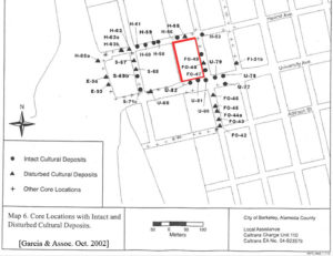 In 2002, Chris Dore drilled core samples in the streets on three sides of Spenger’s parking lot for a city of Berkeley cultural resource assessment related to planned work on the nearby Amtrak train station. Dore’s map shows seven bore holes with “Intact Cultural Deposits” and two with “Disturbed Cultural Deposits” all within a few feet of the property boundary. In the text corresponding to the map (at left), bore hole U-81 has “Very rich shell and ash lens” and U-78 has “Rich shell midden.”
“Our coring identified undisturbed, intact cultural deposits right next to Spenger’s parking lot and wrapping around it,” said Dore in a phone interview on May 14. “How can there be nothing there when there are cultural deposits all around it?”
What we have here is one culture that continues to be fixated on “material evidence” and another that looks at a boundary-less landscape, hears oral tradition, feels an obligation to those who have gone before, and values deeply the spiritual dimension that underlies the material world and eludes our grasping hands and desperate souls.
This is definitely the logic and pattern of colonization. The site is first looted and bulldozed by settlers. The next wave drills a few holes and reports “we can’t find anything” and then claims the right to pillage the site (build on it) because “there is nothing there.” Kill it then claim it. As my mother said, two wrongs don’t make a right.
The developer’s map of bore holes and trenches purporting to “prove” anything about what may lie under 1900 4th St. is actually a tiny sampling of a huge area that goes deep. Another odd element of this saga is that no one can produce a permit that gave permission for the drilling and trenching done by Archeo-Tec for the developer on the Spenger’s parking lot site. It is against the law to damage a registered landmark site without a permit from the Landmarks Commission. Also, ground penetrating radar was used and then the results interpreted to support the developer’s claims. The data have never been shared for peer review. The ground was observed to be wet and it is a well established fact that ground penetrating radar is not reliable if groundwater is present.
Let’s take Blake Griggs at their word. Principal Brad Griggs said his company promised that “we would not move forward if we found any evidence whatsoever of the West Berkeley Shellmound.”
‘The clock is ticking and you must approve the project.’
FICTION: SB 35 applies to this property and demands approval of this proposed project by September 4, 2018.
FACT: Last and not least, perhaps our most important fact: The words “site” and “structure” may save a sacred place in Berkeley.
As you might expect, SB 35 does not apply if a proposed building site is home to an endangered species, is a wetland, has a conservation easement attached, or is a toxic site. SB 35 also exempts landmarked sites, referring to them as “historic structures.” SB 35 text (at Sec. 3 – 65913.4) says the law applies only if: “(7) The development is not located on a site where any of the following apply…(C) The development would require the demolition of a historic structure that was placed on a national, state, or local historic register.” (Emphasis added.)
Lisjan Ohlone leader Corrina Gould asserted recently, in person, to Democratic state Senators Scott Wiener (author of SB 35) and Nancy Skinner (a supporter of SB 35 whose district contains 1900 4th St.), and to the director of the Berkeley Planning Department and City Attorney, that the West Berkeley Shellmound and Village Site is an “historic structure” and therefore is exempt from SB 35. Gould contends that SB 35 excludes historic structures, which reasonably includes the property, associated sites and cultural elements that are part of an historic landmark designation. The 2.2 acres proposed for development is an historic property of recognized, undisputed, outstanding cultural and archaeological significance that is eligible for the National Register of Historic Places. Contrary to assertions by the developer that focus on whether there is or is not proof of shellmound material or burials within the 1900 4th Street property, this decision is not about the shellmound. It is about a prehistoric archaeological site, CA-ALA-307, that is eligible for the National Register, is on the California Register of Historical Resources, a portion of which is City Landmark #227 — all of which entirely encompasses the 1900 4th Street site.
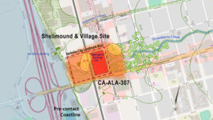
Since it’s a bit hard to visualize all this, here is the single most important map from the sequence above:
Finally, the National Register of Historic Places defines “STRUCTURE” as follows: “The term ‘structure’ is used to distinguish from buildings those functional constructions made usually for purposes other than creating human shelter.” It lists as examples: “bridges, tunnels, gold dredges, firetowers, canals, turbines, dams, power plants, corncribs, silos, roadways, shot towers, windmills, grain elevators, kilns, mounds, cairns, palisade fortifications, earthworks, railroad grades, systems of roadways and paths, boats and ships, railroad locomotives and cars, telescopes, carousels, bandstands, gazebos, and aircraft.” (Emphasis added.)
Additionally, “SITE” is defined as “the location of a significant event, a prehistoric or historic occupation or activity, or a building or structure, whether standing, ruined, or vanished, where the location itself possesses historic, cultural, or archaeological value regardless of the value of any existing structure,” with these examples: “habitation sites, funerary sites, rock shelters, village sites, hunting and fishing sites, ceremonial sites, petroglyphs, rock carvings, gardens, grounds, battlefields, ruins of historic buildings and structures, campsites, sites of treaty signings, trails, areas of land, shipwrecks, cemeteries, designed landscapes, and natural features, such as springs and rock formations, and land areas having cultural significance.” (Emphasis added.)
The developer’s own plans affirm this on page G-1.0 in the column labeled DESCRIPTION: “HISTORIC PRESERVATION: Landmark/Structure of Merit,” where the plans note that that the property at 1900 4th Street is indeed designated a “structure of merit.”
But wait, there’s more! The Berkeley Housing Element 2015-2023 is a 352-page document that officially identifies adequate sites for housing. Page 220 names the parcels identified for housing development, and clearly states that “No city-designated Landmarks or Structures of Merit” are included. As stated above, 1900 4th St. is a well-documented place of cultural significance. The assertion that “the shellmound is not here” just does not hold water given the large amount of physical material that is currently in curation at the Phoebe Hearst Museum that was removed from the site in the past, the number of burials that have been removed during road construction around the parcel, and historic maps of the area. The overwhelming amount of information on the site led to the site being designation as a Landmark 18 years ago so that it would be protected. As such, the site is not eligible to be included in the Berkeley Housing element.
If the City hopes to ever rectify the conflict between the housing designation and the preservation element, it should err on the side of preservation, and only allow housing to be built on sites that are not already designated Landmarks.
Bonus Facts!
 Bottom feeder bonus! If you have made it this far, you get a reward.
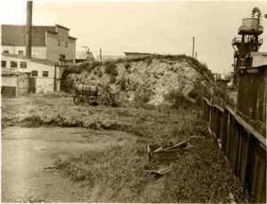
My equally obsessed colleague, Chris Walker, has been looking for old photos that show the shellmound. Until now there has been only one, perhaps taken by Nels Nelson circa 1904-1910 (at right). It shows the main shellmound being eaten away by road-pavers and skull hunters.
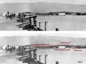
Here (below) is what Chris found, with thanks to Curtis Manning and the Berkeley Historical Society. It’s an 1867 photo looking east from Jacob’s Landing.
P.S. If you have any historic photos of the shellmounds of Berkeley please let us know! Email: slfp@sacredland.org.
For background, please see my previous blog “The Assault Begins on the West Berkeley Shellmound.” Read more about the recent desecrated burials right across the street from 1900 4th St. (just north of Spenger’s Fish Grotto Restaurant) in another blog post.
FYI – all of the developer’s submissions and plans to the Berkeley Planning Department are here. Their website is here.
Information about the site can be found here: West Berkeley Shellmound Facebook Page and Indian People Organizing for Change (IPOC).
Donate to the Shellmound Legal Defense Fund at the brand new website Shellmound.org.
Thanks for your interest!

Blog Post Categories: North America, SLFP News, Threatened Sacred Sites, West Berkeley Shellmound